
TRIP DESCRIPTION
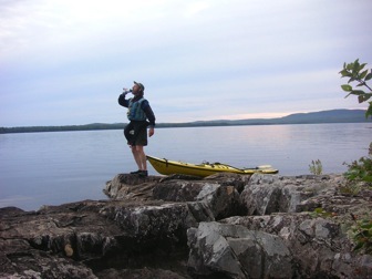
We spent three days and nights making our way north on Moosehead. On the third day our trip was saved by a couple good Samaritans who helped us cross over Northeast Carry to Penobscot Farms (nothing there, just a designation on the map) so we could continue on the West Branch Penobscot. We paddled the West Branch into Lobster Lake and spent two nights at Lobster. We through-paddled to Chesuncook House and laid up there two days waiting for Hurricane Hanna to pass. We caught Chesuncook in a complacent mood, and paddled down to Caribou Point for our last night of camping on the Lake. The eighth day, we ended our trip at the point separating Ripogenus Lake from Chesuncook. We paddled about 90 miles and the dates were 9/1 TO 9/8/2008.
IMPRESSIONS
Lots of great scenery, and lots of clear, open water. Too much open water, could be my only complaint. Well, maybe add mosquitoes, but over many years I have almost totally avoided Maine’s legendary bugs, so I can hardly complain about the two-day onslaught we encountered at Lobster. We paddled past many scenic, and interesting coves, islands, bays, and tributaries. We couldn’t really explore them because of the distances involved in side tripping from our straight-line route which carried us miles offshore.
LOGISTICS
We self-organized and launched the trip. We learned we could launch from town facilities and park across from city hall in Greenville. But we opted to launch from a friend’s camp in nearby Beaver Cove, and parked there. The state-maintained camp sites on Moosehead are free to use on a first come, first serve, basis. The sites are nice (table, privy, fire pit) and appear well used, but we saw very few that were occupied.
It is said that for $20, a lake-to-river portage can be arranged through Raymond’s Store at Northeast Carry. I tried calling and mailing them, but we found this service undependable and had to arrange a good-Samaritan portage. I doubt Raymond’s would have taken us to Penobscot Farm. The road has severe wash outs. Plan on going to another put in.
Bureau of Parks and Lands’ Ranger Tammy stopped by our site on Lobster and collected $21.40 for two nights of camping there. Tammy had cut and stacked firewood we burned while camped there.
We did not stay at any sites on the West Branch, Penobscot, and I don’t know who controls those sites nor the sites on Chesuncook, where we camped one night.
Without reservations, we walked into an evacuated Chesuncook Lake House and rented a cabin at a bargain price, and by coincidence, arranged a bargain-price, car ferry back to Greenville, about an hour’s drive. The best way to communicate with them is by email. Had the Lake House not ferried us, we may have gone with Reeves Alligash Campgrounds (#123 in the Gazetteer, 207-723-9215, $75, without boat) or North Woods Outfitters (207-695-3288 – didn’t price).
The golf course on Kineo rented us clubs to use when we played the nine hole, very picturesque, course there.
We thought NOAA weather radio reached everywhere, but couldn’t pick it up on Lobster Lake. At Chesuncook Village, Steve walked around and found a yard-square “phone booth” where he could pick up NOAA. I’ve heard you can similarly some times find cellular service, but I only had coverage at Sugar Island, and at the southern end of Kineo.
The Greenville Library is located right across from the Town dock on the Lilly Bay Road. Residency is not required for library priveleges, and I was issued an ID number after filling out the form. We checked out Thoreau’s Maine Woods and took it with us. And hey, it was already falling apart when we checked it out. It wasn’t us!
NARRATIVE
MOOSEHEAD is a big lake, and she has many moods. The southern and western edges of the Lake have rustic and rural development, are nice, and we saw more people, mostly on power boats, in those areas. Much of the northern end of Moosehead is surrounded by corporate timber lands. We saw few boats or people north of Kineo, but we could almost always hear the drone of lumber operations, diluting the wilderness feel of the area. Our daily power boat sitings were 9, 22, 7, and 2.
We had a headwind on the first, short leg, from Beaver Cove to Sugar Island, but thereafter the Lake treated us kindly. Janice started out ahead of us in a motorized canoe, but turned back due to the conditions.
There was a heavy fog on the Lake the next morning as we took the kayaks around to the east side of Kineo. We paddled in whiteout, but the mist burned off once the sun got up. As we reached the rock faces of Kineo, the mist lifted away from the cliff faces, and we paddled beneath the breathtakingly scenic uplift. The water at the base of the cliffs is said to be hundreds of feet deep. We beached our kayaks on the pebble beaches forming the narrow ismyth that connects Kineo to the mainland. This placed us near the tee box for the scenic fifth hole of the golf course. We hiked to the club house to rent clubs and pay green fees, and proceeded to wack the little white balls around the nine hole course. It was my first time swinging a club in two years. Thankfully, we didn’t bother to keep score.
The day had developed warm and windless. We debated making the climb up Kineo, but it was already 2pm, and we wanted to get to Big Duck Cove, so we paddled back beneath the cliffs to Hardscrabble Point and packed up our camp. If you are a paddling golfer and decide to stop at Kineo, there is a new set of docks on the southwest side of Kineo that will save you a mile or so of walking between your boat and the clubhouse. It is less scenic than the route we took, but way closer to the club house and the trail head for the hike to the top.
Big Duck Cove is about seven miles and two mountains straight north on the Lake. Here again, our straight-line course carried us into the open Lake, and we had no time to explore. We took our muckles in-boat amid miles of open, pond-flat water. We reached Big Duck Cove just in time to pick a camp site before dusk. Big Duck is a very remote and scenic camping area, but the noise from lumbering operations on the forest lands to the east was a constant reminder that this is a resource extraction area, not a wilderness. We’d been able to hear the noise on Kineo and Sugar Island, too, but it was louder at Big Duck. This is something that probably changes as the location of the lumbering changes.
We were on the water early on Thursday, since we didn’t know how long it would take us to arrange our portage to the West Branch, Penobscot. Out on the Lake, the wind kicked up to about 15mph from the south and we rode the tailwind and waves straight northeast, towards Northeast Carry. Gradually, the large white house that neighbors the road came into view. Again, we were straight-lining across miles of open water, and the wind and waves pushed us up there by mid-morning. We looked south down the line of mountains that line Moosehead. The Lake was behind us.
PORTAGE AT NORTHEAST CARRY. We pulled on our hiking boots and walked the half-mile to Raymond’s Store. Having both called Raymond’s and written them a letter to say we were coming, it was disappointing to hear the proprietor’s curt reply when I asked if we could hire a shuttle: “nope, not today.” What about tomorrow? “Not shuah.” We asked if he thought we could contact a local that might want to earn some cash by helping us out. “Thahs nobody else heah.”
Raymond’s is a small store, maybe 20’x30’, with a formica table for six in the center. I bought some coffee and sat down to ponder. Our boats were heavily loaded. It’d probably take us three trips to carry it all; six miles hauling gear and twelve miles of walking. That’d make an unpleasant day. We considered setting up camp, though it isn’t a designated camp site.
A half hour after entering Raymond’s, we were still pondering options when two customers drove up in an F-250 with a couple rec boats in the bed (these were the only customers who happened by while we were there). We explained our situation to these two Bay-staters and they quickly agreed to ferry us across the Carry. These guys, Wayne and Steve, earned a place in my heart. They dumped out their kayaks and carried us back to the Lake. We were barely able to lift our loaded boats into the pickup. The cockpit of the Azul sat squarely on the tailgate, and I climbed into the bed and sat on the bow to keep it from rocking out. I was a little scared the boat would snap in half as we jounced the mile-and-a-half to the Seboomic Road. From hiking here in 2004, I knew the last half mile of the Carry, down to Penobscot Farms, was much rougher, but I was unprepared for how rough the road had become in the four years since then. There were huge, axle-deep ruts and puddles. Steve’s driving was magnificently gentle, yet my boat still bounced severely in the bed. We came to a severe wash out, and I thought that this was the end of the ride. Steve and Wayne got out and walked the gulley that sliced through the road. Steve decided he could do it and I felt the truck go into low-range 4wd. I was stunned he was able to get through the wash-out as gently as he did, and after that, it was only a few more ruts and small ponds to drive through to get to the River.
At Penobscot Farm we encountered the single most viscous swarm of mosquitoes I ever experienced. Wayne helped me carry my boat to the river, ignoring mosquitoes that landed on his bare legs and arms covering him like body hair. “What else can you do?” he asked. None of us tarried in that environment. We thanked Wayne and Steve profusely and quickly and watched for a moment as the truck disappeared toward the Seboomic Road.
I ripped open a hatch and grabbed my fleece pants, somehow pulling them on over my hiking boots, covering my bare legs. Driven to distraction by the swarm, I leapt into the cockpit, shoved in a few items I was carrying, including my spray skirt, and shoved off. Size twelve hiking boots don’t fit in the cockpit of my kayak. My legs were crossed and toes shoved down beyond the footpegs and I had so much other stuff shoved into the cockpit that I was really crammed in. But on the Penobscot, while the mosquito population was still strong, we paddled away from the swarm and I regained my composure.
PENOBSCOT TO LOBSTER. Thoreau wrote that the spuce and pine spires along the Penobscot were more inspirational than any steeple built by men, and as I floated along the river, it was hard to deny that sentiment. We quickly covered the few miles to the confluence with Lobster Stream, passed under the Seboomic road, and pushed up against a mild current until, rounding a bend, the expanse of Lobster Lake opened before us. We set on a southeast bearing and crossed a mile or two of open water to reach the Ogden North campsite. The couple camped there suggested we use the beach sites around to the south, and that’s what we did.
There were lots of mosquitoes at Lobster, too, but we had to laugh when we unhatched our boats. As we lifted each hatch, five or ten mosquitoes would fly out. We’d trapped them in the hatches when we were escaping the swarm at Penobscot Farm.
We spent two nights at this site. Ranger Tammy had left us a nice stack of precut cedar, and we were able to augment that supply with a few pieces of hardwood, and Steve found a nice “chimney log” that we burned on the second night. We enjoyed waking up to a day when we were not packing up and heading out.
I took a dawn paddle on mist covered Lobster, returned to the site and picked up Steve and we went for an extended day paddle on Lobster. We stopped on Big Island and hiked on the Carin Trail, but had no clue where to find the trail leading up Lobster Mountain. While Small in comparison to Moosehead or Chesuncook, Lobster Lake is big, roughly two miles by five miles. Big Island is two miles long and divides Lobster into Little Claw and Big Claw. We paddled the narrows between the big claw and small claw pinchers and found a flat, rocky spot to pull up for a leisurely, hot lunch. The wind had been building all day and our after lunch trip on the Big Claw was a fast and exciting surf. I was disappointed to not see the other sites on that part of the Lake since I had heard on Paddling.net that they were some nice sites.
Ranger Tammy came by the beach site just as we were packing out, early Saturday morning. She collected $21.40 fees. We thought our weather radio had gone out of service, but Tammy told us we were way out “in the middle of nowhere”, and NOAA’s signal didn’t come in. The weather forecast, per Tammy, was good for the day, but the remnants of Hurricane Hanna were due to arrive around evening, followed by a solid day of rain and winds. We’d talked about possibly spending a night at Chesuncook House, and Steve, Tammy, and I were all in agreement that it might be a fine place to watch a hurricane.
After getting a little lost finding Lobster Stream, we rejoined the Penobscot. The sad part about this part of the trip is that it is only about twenty miles long. Sad, because it is so pleasant and scenic, I wished it would last longer. Thoreau’s Island site looked inviting, but we were running from the storm, and passed it by. We stopped for lunch and leg stretching at the Halfway Point site. As the afternoon wore on, swirls of dark clouds yielded to an early, glooming, dusk. We had a few interludes of spitting rain, but for a hurricane, the weather was pretty fine. We completed the 23 miles to Chesuncook Village at dark.
CHESUNCOOK HOUSE was emptied of guests by the ominous weather forecast. The guests had arrived, and departed, by floatplane, the operators of which had decided to preemptively evacuate. Louisa, proprietess of Chesuncook House suggested a cabin and gave it to us for a super reasonable rate. Chesuncook Village is a collection of 30 or 50 buildings, with nine year-round residents. There is no electric service, and only a very difficult road connects it, by land, to the rest of the world. It is very quiet and peaceful. We found the cabin’s basic accommodations luxurious. We’d been camping since three days prior to the trip, so were grateful for conveniences like the gas stove, screened porch, and indoor plumbing.
It rained some overnight, but the Hurricane never really arrived. Steve’s hands were bothering him and he was generally fatigued, and he wanted to take the day off and spend a second night at the Village, and that’s what we did. I was both sad and happy about this. The wind and weather were ideal for a trip down the Lake, and there was a part of me that just wanted to go. However, after touring the highpoints of Chesuncoook Village (the Store and Graveyard Point), I was glad we stayed. I would not have grasped the remoteness and peace, the sense of history, and the charm of the place.
Thoreau wrote that the immigration of people to the north woods might reverse itself, once the population of lumbermen eliminated the population of pine and spruce. He did not forsee modern timber management practices that would extend the productivity of the forest lands, nor the mechanization of the lumber business, that enables only a few people to perform work that previously required many large crews. Chesuncook Village is an artifact that remains after that reverse immigration of which he wrote. If it is to remain, it will be as a tourist and recreation attraction, and it will probably be snowmobilers that sustain it.
SOUTH ON CHESUNCOOK. Early Monday we packed and launched the kayaks onto Chesuncook, We had a mild tailwind and I looked forward to experiencing Chesuncook’s vaunted waves. A mile or two into the trip, we had a nice 1 – 2 foot following surf, with occaisional larger waves juicing the pace a bit. It was fun and I wondered if it would get bigger as we progressed south. But after a lunch break at Sandy Point camp site, the wind calmed, and we paddled at a more settled pace towards Caribou Point.
On the southern end of Chesuncook, there is a large passage to the southwest and Caribou Lake. To the southeast, there is a large passage to Ripogenes Lake. Dead south, there are a few more miles of Chesuncook. This must be the area of the Lake that gets infamously rough. A southern wind would drive surf from all three bodies, and the waves would interact and combine in unpredictable fashion at midlake. But the day’s wind was moderate and had shifted around to the west, and we had an easy paddle to the Cardiser Point camp site, making camp at midafternoon . The clouds that had been masking nearby Mt. Kathydn cleared, we set up chairs on the rock beach, and initiated happy hour. We were in a celebratory mood, looking at the end or our trip, and gave ourselves double rations of pop corn and whiskey.
All that was left of our trip was to paddle about two miles to the boat launch on the point that separates Chesuncook from Ripogenus Lakes. We were to meet our shuttle there at 10:00, and reached there about 9:50. We’d asked Chesuncook House’s Louisa how we could arrange a ride to Greenville. By coincidence, her husband, Dave, needed to go to Greenville. The only power boat we saw in two days on the Lake came in from the north around 10:00. It was Dave, and he picked up the Surburban he parks there and had us back in Beaver Cove before noon. Dave and Louisa treated us royally and if they charged us any less they would be giving away their services. Plus, Dave carried jumper cables, that we used to get Steve’s truck going. Doesn’t get much better than that.