Going East, 2012
Custer, WA to Gambrills, MD
by Chip Walsh. Last edit 11/19/2012

Custer to San Francisco

I left Custer, Washington on August 5 and went to visit my friend Lisa in Seattle. I hadn't seen her for 5 years, during which time she and her man had bought a house in an old neighborhood and done a ton of rehab on it. I'd been hearing about it from afar so it was great to finally get the tour. We went out to eat at Rays, toured the Chittenden Locks, and had some drinks at the oldest bar in Ballard, the Lock Box.


Next morning, I got up in the dark and jumped in the truck to try and escape the Seattle area before Monday-morning traffic started to build. I was on the road around 6 a.m. I was headed to Eureka, CA, a drive that would take me around 11 hours. The route was south on I-5 to Grants Pass in southeast Oregon, then west on Route 199 to the California coast, finishing out on Route 101, south along the coast to Eureka. I thought I was making good time down I-5, but progress slowed once on 199. The last hundred miles on 101 took a couple hours. But it was a visually interesting drive, passing through Redwood State and National Parks. I was so impressed by the Redwoods that I stopped to take some pictures.
Picture of a roadside redwood
Nobody paints or photographs an entire giant redwood or sequoia tree. It's virtually impossible to see the whole of the things at once.

At right: image of a redwood forest along Rt 199.
Pic of redwood forest off route
              199

The ride down the coast was also very scenic, although I smuggly thought it wasn't such a big deal compared to the BC coast. Later I would learn how wrong I was, because I wasn't appreciating the scale of the cliffs and sea stacks. Gas prices in northern California were in the $4.19 neighborhood, the highest I'd encounter during this 50-day trip.

I arrived at Topher and Tania's house in Eureka early that evening, and was warmly welcomed. Topher kept me busy and took me to so many places I sort of lost track.  After an all day drive, I was ready for a beer and was happy Topher put me on his extra bike for a ride to the Local Beer Bar (that's the name of the place), then had dinner at the Brick & Fire Bistro. On Tuesday, we loaded up kayaks, stopped for breakfast at Cafe Brio in Arcata, then carried on to Trinidad Bay. In Trinidad Bay I realized the rocky coastal features of the northern California coast were very impressive from close range. The swell was moderate, around three feet, enough to give an idea of the fun to be had playing around the cliff faces and sea stacks of the Bay. We spoke to a number of paddlers who were kayak fishing, something Topher is fond of doing, but not today. I was very impressed with Trinidad Bay and regretted leaving my camera behind. Sometime in the remainder of the day we visited The Shanty (dive bar), Kebob Cafe, Pho Tien Long restaurant, and finished up with another stop at the Local Beer Bar. What a great day.

I really enjoyed getting a glimpse of life in Eureka. I have a much better understanding of why Tania and Topher like where they live. The following day (Wednesday, Aug 8) I was off at 6 a.m. for a five-hour drive to San Francisco, where I caught a plane home to attend funeral services for my mother-in-law. I'd intended to be back in San Francisco on Friday, Aug 10, but the airlines had other ideas. Due to various delays, I picked up the truck from airport parking, with the kayak still on it, Sunday morning, Aug 12.

Kings Canyon & Sequoia National Park

I got some house keeping things done in San Francisco on Sunday morning (groceries, oil change) before heading east. I made for Kings Canyon/Sequoia National Park, which is really just one Park. From Fresno, I went into the park on CA 180. This was probably a bad routing decision because I ended up back tracking on the Generals Highway and would have been better off entering the park on the south end via CA 198, and leaving on 180.

It was a hundred-degree day in California's Central Valley. Regardless, as I headed east out of Fresno I switched off the air conditioning in the car and got hot. I wanted to feel the change in temperature as I drove up to Kings Canyon. It worked as advertised and the temperature went from baking to comfortable as the truck climbed 5,000 feet in elevation, up to over 7,000'. Temps in the valley were around 100 degrees, but at elevation it was very comfortable, perhaps 80. I passed many scenic overlooks, but it was so hazy I didn't bother to take pictures. I had spent the whole day driving and camped at the Azalea campground in Kings Canyon.

I didn't realize it until later, but there were a number of large fires burning in the northwest, and the haze, which would stay with me as I went east, was a result of the fires.

At 8:30 Monday morning I was at Grant Grove in Kings Canyon. The temperature was pleasantly cool at that hour, and I had the place to myself. I liked it so well I walked the pathway loop two times, lingering in awe among the giant Sequoias. It felt like church to be in the presence of those thousand-plus year old organisms, the largest living things on earth. The General Grant tree is the second largest living thing in the world in terms of mass.

The Redwoods didn't seem as giant after seeing the Sequoias.

Picture of the general grant tree
Sequoias live over a thousand years because they are tough. They survive fires and even in death they last a long time. The hollow-core Michigan tree has been laying on the ground for a hundred years. Tourists like me entertain themselves by walking through it. Picture of the 100-year dead,
              Michigan Tree
Leaving Grant Grove, I headed down Generals Highway to the Land of the Giants. National Park legend John Muir explored the Sequoia forests in 1873 and 1874. When he came to this grove of Sequoias, he called it the Land of Giants. There are a number of huge trees, including the General Sherman, the largest living organism in the world. These trees are not the tallest trees, but in terms of mass, are the largest, and they are massive! General Shermans' stats: Height: 275', Base diameter: 36', Circumference at ground 103', Height of first branch: 130'. It is estimated to weigh 2.5 million pounds and be around 2,500 years old.

The Sherman tree is just one of the biggies in this forest. I got some folks to take my picture with "The President." I started walking The Congress Trail and I was awed by big tree after big tree, but my walk was cut short after about a mile because the trail was closed due to "burning operations." I retraced my steps and was back in to the truck by about 3 pm.
Picture of Chip, dwarfed by the
              massive trunk of the President

I had intended to end the day with a hike into the Kings Canyon back country, but the trip back north on Generals Highway was delayed first by construction and then by a tree down across the road. As a result, I missed getting to the permit office before they closed. The views going northbound on Generals Highway were much more impressive than when I was going south to the Land of the Giants. I camped at Crystal Springs campground in Kings Canyon, which had a surprisingly different character than Azalea. I was asleep, beneath a "small" sequoia, at sundown.

Yosemite

On Tuesday, 14 Aug, I left Crystal Springs before 7 am, taking Rt. 180 almost all the way back to Fresno. Maybe it was having the sun at my back, but the views leaving Kings Canyon were much more dramatic than arriving. It had been chilly overnight, but as I descended about 6,000 feet into the valley, it got hot. I turned north on highway 41, stopping for a couple hours in what appeared to be the last major town before Yosemite: Oakhurst. I found a Starbucks so I could use the wi-fi--I needed to pay my credit card, gassed up, found a Post Office and mailed some stuff. Then I began driving up into Yosemite, again, with the AC turned off. I could feel it cooling as I drove up past roadside signs marking off thousand-foot contour intervals.

Entering Yosemite, there were no campground status signs like other parks have to list where camp sites are available. The first campground I passed was marked "full." I took the road to Glacier Point. Eight miles up the Glacier Point road was the Bridalvale campground, also marked "full." But, I needed to pee so I drove into the campground to use the latrine. As I was leaving, I noticed site #89 was empty and untagged, so I hurried back to the campground entrance and grabbed a registration envelope, then hurried back to #89 and tagged it. The park was full of summer tourists so it was a relief to have secured a site.

I found a ranger at the Bridalvale registration area, she gave me some park literature and after talking things over with her, I settled on a touring plan. I would spend the remainder of the day touring Yosemite Valley, returning to catch sunset at Glacier Point. Then on the following day I would head into the Yosemite "high country" and make an overnight backpacking trip.

In the Valley, the dry conditions resulting from last winter's light snow pack left Yosemite Falls, one of the park's premier attractions, completely dry. So, I headed to Vernal Falls. I parked near Curry Village and started walking to the trail head for Vernal Falls. I spent about two hours on the trek to the top of Vernal Falls via the Mist Trail. Vernal Falls trail
This walk had a thousand feet of elevation gain, but seemed easy. The surface was paved for much of the way. Even with what must be very low water flow, the falls were impressive. Later, I'd wish that I had continued further up the trail to Nevada Falls, but I headed back to the Valley loop road and caught a shuttle bus. Pic of Chip at Vernal Falls
Catching the shuttle bus was poor time-management for me. The bus went around the loop road in a counter-clockwise direction. On the bus I looked at the Park's publication and decided there were really no other features I wanted to see in the valley. The bus was crawling and I got off and hiked back across the loop. When I got back to the truck I had to drive around the loop road again. I parked near the El Capitan Bridge and went for a dip in the Merced River. Looking around at this spot the majesty of the Valley finally struck me. The trouble with driving was I wasn't really appreciating what I was seeing. Picture of Chip, dwarfed by the
              massive trunk of the President
I wanted to on the way to Glacier Point by 7pm, so I headed toward my campground, which required passing through a tunnel on Wawona Road. As I approached the tunnel, I noticed many cars stopped at the overlook, and I stopped there, too. The area is called "Tunnel View," a name which becomes obvious once you stop there and look at the fabulous (but hazy) view of the Valley. Pic taken at Tunnel View
I achieved my goal of being enroute to Glacier Point by 7pm. The day had become overcast and it sprinkled rain now and then. As I drove the sun appeared beneath the cloud layer and I feared I might be too late to catch sunset. I sped up and surprisingly encountered no slow moving vehicles on the 16-mile climb to Glacier Point, but there was no sunset to be seen in the hazy, grey distance, just sumptuous views of the Yosemite Valley. From the point I could see Nevada Falls and realized I should have kept hiking beyond Vernal Falls. Half Dome dominated the skyline. Darkness was upon me as I returned 8 miles down Glacier Point Road to campsite #89. Pic: View from Glacier Point

On this day I had heard more foreign languages (beyond Spanish) being spoken than I had ever heard in the U.S. I think half the tourists in Yosemite were foreigners.

It being well past sunset, at #89 I whipped up instant camp food in a bag: Louisiana Red Beans and Rice. It was too salty, but still pretty good, and I had no problem eating the bag's alleged two servings. It had gotten cold by the time I crawled into the cocoon of the truck's cap.

Random Recommendation of a musical group: Trampled by Turtles - recommended by James at Bridalvale Campground. James and his buddy had stopped by Yosemite on the way home from a music festival.

Temps were in the thirties when I awoke on Wednesday, 15 August, but it warmed up once the sun got over the hills. I headed for the northeast quadrant of the park, into the "high country." It was a beauty of a day with blue sky and sunshine. The Tunnel View was not as impressive as late on Tuesday, but the sun on the Valley was impressive and I took a few pictures. Pic: Roadside view on sunny
              morning

Also stopped for a few pictures along the Tioga Road, and it took me three hours to get to the Tuolumne Visitors Center.
Pic: Chip at Olmstead Pt, Half dome
              in distance over shoulder

At Tuolumne Visitors Center, I went to the permits office and debated with myself on backpacking destinations: mountain lake or valley falls? Having hiked to a mountain lake in Grand Teton, I opted for the valley and pulled a permit for Glen Aulin.  The trailhead is at Tuolumne Meadows, elevation 8,600', and the trail drops 600' over 5 miles. At Tuolumne Meadows, all the parking areas and roadsides were packed. Finally somebody pulled out from the roadside and I grabbed a spot.

Yosemite's rangers and signage make a big deal of Bear protocol, i.e., not leaving any food in your car or anywhere else bears can get at it . There are bear lockers along the roadside, and you are supposed to leave your food there. Being prepared to be on the road for weeks, I had a lot of food. I hoped nobody would mess with it as I crammed items among other people's stuff in several food lockers, since the lockers were already mostly full and no single locker had enough empty space for my stuff.

Does packing always take two hours? Seems to, even if it is just down-selecting gear and food out of the truck. So, it was 3:30 by the time I started walking to Glen Aulin.  The back country of the Sierras was very scenic. I made it to Glen Aulin by dark, made a day hike to Waterwheel Falls the next day, and then came back to the truck around 9:30 on Friday, 17 August. For more detail and some pictures from this part of my trip, you can check out Hiking Yosemite's Glen Aulin Area.

Back at the truck, I was happy to see the kayak was still on the truck, and I was happy to retrieve all my food items from the bear lockers. It seems stunning that these lockers are not regularly pilfered. I pointed the truck north on Tioga Road and made my way out of Yosemite amid light traffic. It was Friday and there was lots of traffic coming into the park.

Lake Tahoe

The drive from Yosemite to Tahoe was scenic. I stopped and took pictures a few times. In Topaz, Ca, I stopped for gas and a nice sub from Port of Subs--my first try on that western-states, chain restaurant. In South Lake Tahoe, I made my way around to the southwest side of the Lake, heading for D.L. Bliss State Park. Traffic was heavy. It was summer, Tahoe is a resort area, and the tourists were here in force (me included!). When I got to D.L. Bliss, the park was full and not admitting anybody. But it was clouding up and spitting rain, so I figured I may as well wait as people were likely to be leaving, and indeed, cars were exiting. But there is a difference between cars leaving and the boneheads at the gate deciding the park was no longer full, and I waited over an hour. I was parked within sight of the gate. The gate personnel told me they'd let me know when I could go in, but they didn't do so until I walked over and prompted them.

At the beach, I geared up to kayak and carried the boat over to the beach. I heard a rumble of thunder and asked some beach-goers if they were concerned about lightning. They said, basically, "huh?" I launched but wasn't on the water for five minutes before there was more thunder and it got very dark in the direction I wanted to go (towards Emerald Bay). I went back to the beach, where the beach-goers were still unconcerned and gave me a beer. I was in the middle of an animated discussion (gay marriage) with a nice San Francisco-ite when the rest of her party decided they needed to get off the beach. They almost had to drag her away. It rained and thundered. I sat it out in the truck. Pic: Storm Clouds over opulescent
              Lake Tahoe

The weather cleared and I re-launched about 5:00. I paddled the three miles over to Emerald Bay, and I wanted to paddle to the west end of the Bay, but it was so late I decided not to. I did beach at a nice spot on the northeast end of Emerald Bay. It looked like a nice spot to camp, but I guessed it would not be legal. So, I spent many hours at D.L. Bliss for a short but rewarding paddle. The huge lake has amazing clear water and a scenic lakeside, so it is easy to understand why people become enraptured by kayaking Lake Tahoe.

I'd been warned that the campgrounds would be packed on a summer Friday night, and indeed, that was the case. So, I'd arranged for an inexpensive hotel room in Reno, Nv. It took at least an hour to slog through traffic in South Lake Tahoe, and I didn't get to Reno until after 10:00.

East on the Loneliest Road

I looked for a place to grab some food on the way out of Reno on Saturday morning. There sure are lots of bars and casinos in Reno, but there sure was no place for a vegan to eat. I finally bought some bread at a 7-11 and made a peanut butter sandwich. Then it was back to the highway, I-80 to Fernley, Nv, where I picked up Route 50, the road that is billed as "the loneliest road in America."

"Loneliest Road" seemed like hyperbole for the first half hour as I passed through Fallon and Nevada City, but the further east I went, the more deserted the road became. I was en route to Great Basin National Park, in eastern Nevada, and my route included 330 miles on 50, a dual-lane road that tracks through the Nevada desert, going straight for 10-20 miles at a stretch, through flat or gently sloping terrain. Rabbit weed and sage provide a uniform landscape for ten miles on both sides of the road and there is no traffic for miles at a time. The road in front of me was as straight and empty as the road in the rear view. I began to believe it might be the loneliest road. Every 20 or 30 miles, Route 50 climbs up a mountain range to 6,500 or 7,000 feet. Then it descends for a run of 20 or 30 miles to the next mountain range. Pic: View from the lonliest road

The Great Basin Desert extends from California's Sierra Nevada Mountains to the Rocky Mountains, covering almost all of Nevada and about half of Utah. Before the oceans receded, it was sea floor. Now it is high desert. There are a great many fault lines running north-south through the great basin, faults that have risen on one side as the other side sank. Seismic activity along the fault lines produced what today are mountain ranges that break up the Great Basin. Ten thousand years ago, the mountains were covered with glaciers and the valleys were home to forests. But as the climate warmed, the glaciers melted, and the valleys dried up. The forests and animal life retreated into the mountains. The Sierra Nevadas to the west strain most of the moisture out of the prevailing west winds, but in the winter enough snow falls on the desert mountains to sustain what remains of the plant and animal life. Any water that falls in the Great Basin is either absorbed by the ground, evaporates or collects in lakes. There are no rivers carrying runoff to the sea, and that is why it is named the Great Basin. I include this short, and not necessarily accurate, tutorial here to explain why the east-west traveler (me!) encounters row after row of mountains with flat deserts interspersed between.

It occurred to me that on this road there were no trees or bushes to duck behind if I needed to pee. I didn't have to go, and I suppose you could just stop and go in the middle of the road. As these thoughts were processing through my brain, Route 50 led into the town of Austin, Nv., population 192. The speed limit dropped as 50 passed through the town, and when I spotted the Toiyabe Cafe, I decided it was time for lunch, and a pee break. There was nothing on the menu for a vegan, but I struck it lucky in that the soup of the day was a veggie noodle soup.

Somewhere east of Austin, hours later, I actually did have to pee. I pulled over and got out of the car, and wouldn't you know it, another car came along. They saw me on the side of the road and hit the breaks, turned around and came back. I could only think a robbery was going to occur. But no, it was just a guy named Don Cucarola, with his wife. Don wanted to talk about kayaking. How crazy was that, and who said this road was lonely?

Back on the "loneliest road" for several more hours, I arrived in Baker, Nv (population 363) about 8:00. I was confused by the road signs in Baker, but there was a bar conveniently located a few hundred yards from the intersection. I went there and found the only two customers sitting at a table outside. It looked like it would have been an interesting place to sit and have a beer, but the customers clarified the road signage, and I figured I should go find a camp site while there was still a bit of daylight. From the bar, it was only about five miles to the Lower Lehman campground in Great Basin National Park, and I settled into site number 10.

Great Basin National Park

Great Basin, which I had never heard of, is a really nice National Park. Even though it was a weekend, it was not at all crowded, which is a good thing because the campgrounds and other facilities are relatively small. I attribute this to the Park's anonymity and driving distance from population centers. It is also a new park, only receiving National Park status in 1986. Most of the Park lies above 7,000', so summer temperatures were moderate.

Lehman Cave lies within GBNP, and on Sunday, 19 August, that's were I started my touring. I was required to sanitize my shoes because I had worn them while touring Wind Cave in July, and the Park Service is trying to stop the spread of disease (white nose syndrome) that is killing off bat populations. I had to sit for five minutes with my feet immersed about an inch deep in a tub of disinfectant. My 90-minute tour was led by an entertaining park ranger. She told of Mr. Lehman, discoverer and first owner of the cave, who for a dollar let people go in for up to 24 hours. Now, the Park Service doesn't want you to touch anything in the cave. Back then, Lehman's policy was, "if you can break it you can take it." During prohibition, they ran a speak-easy in the cave, with a dance band. I can't imagine walking around down there with a buzz.

There was a cave enthusiast on the tour who told me this was a very impressive cave with an incredible volume and variety of cave formations unmatched in the many caves she had toured.
Pic: Rare, shield formation in
              Lehman Cave
After the cave tour I walked the 0.3-mile interpretative trail at the Lehman Cave Visitor Center before heading up the Wheeler Peak scenic drive. The trail was signed to identify the types of vegetation in the park.

Wheeler Peak tops out at 13,000', and the road carried me up to a campground and trailheads at 10,000'. The day had started off with beautiful weather but clouded up and rained as I drove up the mountain. The rain let up, but it was cold up there. I hiked the 0.4-mile, Sky Island interpretive trail and the 2.7-mile, Alpine Lakes loop trail.
Pic: View of Mt Wheeler
The weather had cleared up and I was hoping to take a dip in one of the two alpine lakes on the latter trail (Teresa and Stella Lakes), but the western drought had left them more like shallow puddles than lakes, so I passed on the swim.

The image at right is Stella Lake. The camera didn't quite capture the sickly green color. That's not what Alpine lakes should look like.
Pic: Stella Lake was merely a
              puddle

It was about 7 p.m. by the time I made my way back to site 10. This was the eastern part of the Pacific Time Zone, and darkness came early, by about 8. The skies cleared, revealing a sky filled with cut diamonds, among the most brilliant star scape I'd ever seen. The combination of high altitude and distance from the light pollution of populated areas make for a stunning night sky.

It was chilly that night and in the morning I waited for the sun to shine on site 10. A little brook babbled behind the campsite. Having foregone the swim in Stella Lake and in need of a bath (no showers at the campground), I slid into a wooded spot and ladled ice-cold water over my head for a rustic shower. Chilling, but effective, and I emerged from the woods minty fresh.

East to Utah

Anticipating Utah liquor laws, I stopped in Baker and picked up a six pack of beer.  Out of Baker, Nv., I took Nevada  487 to Utah Rt. 21. I was no longer on the loneliest road in America, but Rt. 21 must not be far behind. It was 75 miles of deserts interspersed with mountain ranges to the next town, Milford, Utah. I stopped at a small, white, cinder block building signed "Brody's Tacos." There wasn't much on the menu for me, but I explained my veganish diet to the proprietor, a Mexican guy that reminded me of a young David Hidalgo. He smiled and suggested they whip up a veggie, rice, bean burrito for me. His mother and cousin in the kitchen made me a great lunch. Industry in Milford was mostly agriculture and apparently some mining is opening up. I eased dropped on the other party in Brody's, a trucker and his buddy, talking about hauling grain and possible mining business. I enjoyed stopping in restaurants in little, out-of-the-way towns, and this was one. Pic: Utah Rt 21

In Beaver, Ut, I hit I-15, jogged north, and then got on I-70 where it starts at Cove Fort, Ut. This was kind of historic for me, because in the east, I-70 terminates just outside Baltimore, near home, and I had never seen its western terminus. But I was only on interstates for about an hour, then got off and worked my way across routes 118 and 119 to 24, which ran to Capital Reef National Park. I arrived there about 5:00, only forgot that I'd crossed into Mountain Time, which made it 6:00.

Capitol Reef National Park

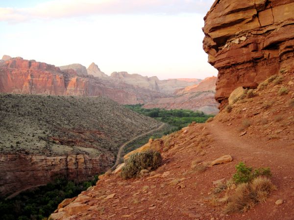
There is a hiking trail that runs between the campground and the 20-yard wide Fremont River. After eating dinner I got on the trail and followed it as it winds up into the red rocks. It was a scenic introduction to the Park. It was kind of hot upon arrival, but cooled to perfect sleeping weather as the night grew dark. Pic: View from the Fremont River
              Trail
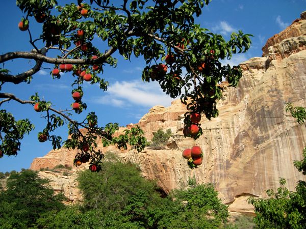
The Mormons who settled the area in the late 1800s planted orchards and named the town Fruita. They grew apples at first but eventually grew a dozen different fruits and nuts. Only ten families lived here when FDR signed the law making Capital Reef a National Park, which ended it for the families. But apparently, the Park Service does what it takes to keep the orchards producing, and it was my good fortune that Tuesday, 21 August, the morning after I arrived, was the day they opened the peach orchards for picking. I love peaches, but almost never buy them at the store because they are sold green and hard, and almost always rot while I wait for them to ripen. IMO, the only way to eat a peach is fresh off the tree.

Picking opened at 9:00 and was in full swing when I arrived about 9:30. Peaches eaten in the orchard are free and they cost a dollar a pound to take with you. Two local ladies were wheeling a cart with about 50 pounds out as I arrived, emptied the cart, and went back for more. They do this every year and put up preserves plus cook peach cobbler, pie, and so forth. The Park Service had picking poles to borrow. These were poles with a wire basket on the end, and the open end of the basket had little tines or fingers to hook the peach so it would tumble into the little basket. But I didn't even need the pole as there was plenty of low hanging fruit. The peaches were perfectly ripe, and the Park Service lady told me they are not sprayed, so I ate them right off the tree. Soon, my fingers and beard were covered with peach juices and I wondered if a person could get sick from eating too many peaches. I took a few for later, but ripe peaches don't keep in a hot truck too well, so I restrained myself from taking more.
Pic: Perfect peaches, ripe for the
              picking
Just up the street from the peach orchard there were roadside pull-outs and displays about the petroglyphs left behind by the Freemont Indians. So, I stopped there to check out the "Indian graffiti."

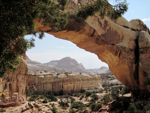
Also nearby was a mile-long trail to Hickman Natural Bridge. Becoming more and more acclimated to elevation, I made the moderately strenuous walk without wheezing (2 miles, round trip). Hickman is a huge arch and provided great views.
Pic: Partial view of Hickman
              Bridge
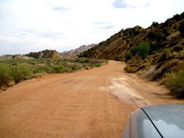
There are some scenic drives that I took--ten miles of dusty dirt roads with awesome views of the colored rock mountain walls, and that was about it for the main touring areas of Capitol Reef, but I wasn't done with it yet. A geologic feature named the Waterpocket Fold runs through the Park. It is a 100-mile long monocline, rock layers all sloping downward in the same direction, or, basically, a big fold in the earth. The main attractions of Capitol Reef are on the west side of the fold, but there is an unpaved road that runs the length of the Waterpocket Fold on its east side, and 24 miles down this road (Notom-Bullfrog Road) there is the Cedar Mesa primitive campground. I had thoughts of staying there Tuesday night.

Image at right shows the Notom-Bullfrog Road. Another candidate for loneliest road?
Pic: Another lonely road candidate

Rangers told me they thought I should be able to negotiate the Notom-Bullfrog Road in my two-wheel drive truck. They thought the only difficulty might be where washes crossed the road, especially if there were rains up in the canyons. It seems strange that in an arid region, you have to worry about flash floods, but they say summer thunderstorms always present that danger. I had no problem reaching Cedar Mesa Campground, arriving mid afternoon. There were five campsites there, set among low Pinyon and Juniper trees, and nobody was camped there. The campground was on top of the Fold, and if you hiked west a bit there were nice views overlooking the valley below. I listened to the weather radio and heard the forecast calling for localized, strong, afternoon thunderstorms. This gave me two concerns. First, I felt the campground was exposed to lightning. Second, I worried that water would turn one of the washes on the road into a muddy mess so that getting out the following morning might be a problem. So, I climbed back in the truck and drove the rest of the 50 miles to Bullfrog, Utah.
The Notom-Bullfrog Road is another contender, imo, for the loneliest road designation. One vehicle passed in the opposite direction, and I passed one slow-moving vehicle going south. This was not a place where I'd want to be stranded. Only one wash appeared muddy and potentially troublesome. I hit it with plenty of momentum and sailed through it. The Notom Road eventually merged with Burr Trail Road and after a while there is pavement, and then I hit Utah 276, and I followed it down to the Glen Canyon Recreation Area (Lake Powell) at Bullfrog, Utah.

Image at right was taken from the Burr Trail Road as it approached Bullfrog.
Pic: Side of the road view
              approaching GCRA
Glen Canyon Recreation Area

I found Bullfrog, Utah unsettling. The area is an access point for Lake Powell. The area is red-dirt desert. It is very small. There was a service station-convenience store, some marine service companies, a lodge, a nice camping area, a Visitors Center, and a primitive campsite. There are several parking areas with many parked cars. There is an expansive marina complex with hundreds of slips, and hundreds of boats. House boats are hugely popular and make up the majority of the boats I saw at moorings. There are very few people. I felt like it was a scene from a post-Armageddon movie, and all the cars and boats had been left behind but all the people had somehow disappeared.
Pic: Parked cars, no people

The Glen Canyon Dam forms Lake Powell in the Glen Canyon Recreation Area. The backwater of the Colorado at the dam stretches 100 miles up the Glen Canyon, which is famous for colorful rock cliffs and extensive side canyons. Apparently the hundreds of parked cars were left by people that had taken boats north on the Lake for multi-day trips. If all the people on the Lake came back at the same time, there would be pandemonium. But coming and going a few at a time, it made the place feel like a ghost town.

I went out and looked at the primitive camp sites near Bullfrog. The campground was on a moonscape of rolling red rock and dusty dirt hills. A very rough, pot-holed, dirt road ran through a series of seemingly random-placed out-houses and eventually lead down to the Lake. There were about three RVs set up down by the Lake. If you don't have an on-board bathroom, you are required to camp within 100 yards of an outhouse. What wasn't rock was fine red dirt, and there was no plant life. I thought it was going to rain. Probably not a lot, but I pictured a quagmire of red mud splashed on everything. I really didn't want to camp there. I went down to the Lake thinking to swim, but a stiff wind was driving foot-plus chop onto the beach and for ten yards out from the shore the Lake looked like swirling red mud. I'd be dirtier coming out than when I went in. I headed back to the developed camp sites.

The developed campsites were very nice. There were three loops with about 25 sites each and a modern, attractive, stucco bathroom facility located in the center of each loop. I particularly liked the outdoor sink/dish washing facility. It was already late and darkening while I fixed myself some dinner, and after I ate I walked up to the bathroom facility in the closed camping loop, stripped naked and gave myself a bath at the outdoor washing facility. The air temperature was still warm and the low, desert humidity cooled and dried me. It was a perfect way to end the day even though it started lightly raining. It pitter-pattered rain for an hour or two, but it didn't amount to much actual rainfall.

The next morning (8/22) I thought I would paddle on Lake Powell. But it quickly got uncomfortably hot, and what I had scene of the Lake seemed big, open and featureless. I opted to give up the idea of paddling and headed for the ferry that would take me to Halls Landing, on the east side of Lake Powell. I narrowly missed the 10:00 ferry and had to wait until noon for the next ferry. The noon ferry arrived, discharging one car. I think the capacity was around 25 cars. Two other vehicles besides me rolled onto the ferry. The ferry cost $25, cash only. As the ferry carried me across the Lake what I saw of the lakeside made me feel I should have paddled, and I regret not kayaking there. Pic: Small Ferry across Lake
              Powell
I took route 276 out of Halls Landing, then a succession of dual lane highways that all could qualify for at least honorable mention in a loneliest roads competition--276 to 95, to 163, to 191 and eventually into Bluff, Utah. But, before Bluff, I diverted off 95 and made a driving tour of Natural Bridges National Monument. Natural Bridges is another hidden gem of a park, and an example of why one should undertake cross-country drives with no agenda or trip deadlines.  I should have hiked the canyons in this park and stayed at least overnight. But I had a firm date when I wanted to be back in Maryland, so I satisfied myself with the driving tour. I did stop at the overlooks and walked down into the canyon below Owachomo bridge to take the photo at right. The trails looked so inviting I wanted to keep going. And by the time I was there I'd been in the high country for weeks, my body was used to the altitude and I could walk without weezing. When might that happen again?
Pic: Chip posing with Owachomo
              Bridge in background

Back in the truck, I continued the lonely roads tour into the aptly named Bluff. One doesn't need to ask to understand why the place is named Bluff, and I don't think it had anything to do with poker. Rather, the nearby San Juan River has carved it's way into the Comb Ridge Sandstone formation (another 100-plus-mile long monocline), leaving a sandy plane between 300' rock walls, and Bluff sits there on the plane, between the bluffs. These dramatic reddish rock walls are the backdrop for everything in Bluff. Praise be to AT&T, there was cellular coverage in Bluff and I searched on the iPhone for a place to eat. I ended up at Twin Rocks Cafe, also obviously named--when I got out of the truck my eyes were immediately drawn to the two hoodoos (rock towers 100' to 200' tall) that backstopped the Cafe. They fixed me an off-menu, fabulous veggie dinner.

After eating, there was still lots of daylight and I hopped in the truck and headed east. The routing on Utah 162 carried me across the Colorado line to Col 41, then 160, and eventually to Col 491, where I stopped for gas at Towaoc, on the Ute Indian Reservation. I also popped into the Ute Casino there to look for information. I'd heard good things about touring the ancient Indian cliff dwellings on the reservation with an Ute Indian guide. The information desk at the casino wasn't much use but I did pick up a couple of brochures. The brochures made it sound wonderful, but were also short on information, and calling the listed phone numbers produced nothing but dead ends. So I gave up the idea of touring with the Utes and drove to Mesa Verde National Park, about 30 miles away. I arrived about 9pm and forked over $30 for two nights camping, the most I paid for a NP campground on this trip. There was more traffic in Colorado. The lonely roads tour was over.

Mesa Verde National Park

It was delightfully cool overnight at Mesa Verde. The campground elevation is about 7,000', and most of the Park is above that--up to 8,500'. The visitor center is up towards 8,500', and on August 23, that was my first stop, to get a $3 ticket for the Cliff Palace tour. A Ranger named Tom led the tour of about 25 tourists. The tour descended a narrow, steep trail with uneven steps that revealed many of the tourist, including kids, were in abhorrent physical condition. Apparently, the removal of gum from the trails and ruins is a problem. Gum chewing is prohibited and it was hilarious when Ranger Tom busted a German kid for chewing gum. The kid feigned ignorance, and Ranger Tom broke into German, apparently making it clear to the kid, who turned red with embarrassment and properly disposed of his gum.

Ranger Tom did a fantastic job explaining Pueblo culture, life, and the challenges the Park Service faces in preserving Cliff Palace. Portions of Cliff Palace are built on fill, and that part is sliding downhill due to it's weight and increases in the amount of water flowing through the sandstone. I was amazed that the Indians originally lived and farmed on top of the mesa, but later on built and retreated to the cliff dwellings in defense of attack. I don't think it is known from who the Indians were defending, but the implication was that other Indian tribes raided. The cliff dwellings are more than 800 years old, so it definitely was not European settlers doing the raiding. Cliff Palace had more than 150 rooms crammed into the space available under an overhanging cliff face. Pic: Cliff Palace
The weather was cool and partly sunny during the Cliff Palace tour, but was cold and rainy thereafter. There are scenic loop drives in Mesa Verde that take you by numerous other cliff dwellings. The Park Service has done a great job in Mesa Verde, erecting many interpretative displays and archeological excavations of various Pueblo dwellings. The displays illustrated how Pueblo dwellings evolved over time from stand-alone, dug-in, stick and mud structures to communal adobes, all of which were on the mesa tops. Around 1200, the Indians moved from the mesa tops into the cliff dwellings, and around 1300 they vacated the area, for unknown reasons.

Photo at right was taken from an overlook on the loop tour. The fire blackened tree-stubble on top of the mesa is what remains from a forest fire, likely caused by lightning. The reduction in water taken up by the vegetation on the mesa top allows more water to penetrate into the soil. This is why there is more water working its way through the mesa. The increased water has reduced the stability of Cliff Palace.

Pic: Cliff dwelling: "Oak Tree
              House"

I spent the whole day driving around the loop roads and stopping at every overlook and display. The rain came and went, but the rain jacket stayed mostly on because it was chilly and windy. I'd been to Colorado a number of times before, had thought about coming to see the Indain ruins, but it is such a long trip from Denver and Boulder to get down to the southwest corner of the state that I could never fit it in. So, it was gratifying to finally see the cliff dwellings and I really enjoyed my day here, despite the poor weather.

Chilled and with it raining on and off, I didn't feel like cooking out. I drove down the mountain to Cortez, Co. and sought out the Main Street Brewery I'd noticed in passing en route to Mesa Verde. Both the beer and the food were disappointingly bland. The weather had cleared and stars were shining by the time I got back to the campground. Despite disappointment at the brew pub, I was very glad to have finally toured Mesa Verde.

East in Colorado

In the morning, I stopped at Moorefield Village--a few buildings housing restaurant, store, and shower facilities for the campground. I showered and went off diet for a pancake breakfast. It was Friday, 24 August, and I was heading east again, on route 160, again, a nice road for a state route. In Durango there was good cellular service and I pulled over to call Bob Anderson, a friend of the family from back east. It was disappointing to hear he was planning to leave town after work for a weekend camping and mountain climbing, but he did give me a scenic drive recommendation and also mentioned that my favorite band, Los Lobos, was performing that night at Adams State. Considering that I expected the scenic mountain route to be shrouded in clouds and rain, I decided against the scenic drive, opting instead to go to Great Sand Dunes National Park, 175 miles east. The route was scenic, and that made me think Bob's suggested route must have been very scenic. But it did rain some in the mountain passes, making the visibility horrid. In the small town of Monte Vista (population 4,500) I found Nino's Mexican restaurant. I must say I liked the Mexican restaurants in the Southwest. All I stopped at were good and Nino's was no exception. Nearing Great Sand Dunes, I passed through Alamosa, and noticed the signs for Adams State.

I arrived at Great Sand Dunes National Park by mid-afternoon. At the campsite I set up a clothesline and hung up yesterday's wet stuff to dry. By 5:30 I was hiking up the dunes, the largest in North America. Again, I was pleased and amazed at my cardio response. The hike started at 8,200 feet and I was able to hike continuously to the highest part of the dunes without feeling winded. It had rained at the Park within the past day and the dunes were easier to walk because some of the surface was still very firm. This made it much easier than hiking in loose, soft sand. The water also left dark bands on the sand that looked very dramatic. There were people on the dunes using sand sleds to zip down the huge dunes. It looked fun, but I had to think it would be painful if one came off the sled at speed. I marched up to the tallest dune I could find and was amazed at the wind, which had to be 30 or 40 mph. I actually feared getting blown off the dune. There were great views from the dune top. There are people climbing in the image at right, but the scale is so huge that you can only see them on the bump in the foreground.
Pic: Among the great sand dunes

Going down the dunes was huge fun. I took giant steps. The sand cushioned the landing and my foot would continue sliding forward, similar to snow shoeing through mounds of deep snow. It brought back memories of running down dunes in Cape Cod when I was a kid, except I can't run anymore and these dunes went on for a lot, lot longer. I made it back to the truck by 7:00 and headed to Alamosa.

Los Lobos at Adams State University

In Alamosa I found my way to Adams State and parked on a street nearby the Stadium. The grandstand was already full when I got there but there was almost nobody in front of the stage, set on the football field. I went back to the truck and retrieved my camp chair, which would turn out to be a wasted trip, because as soon as the show started everybody was on their feet. And who should I run into there in front of the stage but Bob Anderson. In our phone call earlier that day he had neglected to mention that between work and departure for his camping trip he was stopping by the concert. That was amazing and great to run into him. He lives near Alamosa and it would have been a shame to pass so close and not see him.

The concert was good. Los Lobos played for about two hours and their set list was heavy with songs sung in Spanish. Alamosa is a town with a large number of businesses and restaurants having Hispanic names, so this was probably appropriate. This was Bob's first exposure to Los Lobos. He is a former Dead Head, so I told him to keep an ear out for Grateful Dead covers, which Los Lobos almost always include in their sets. They played Good Lovin, and apparently a few bars of Love Light. I missed the transition to Love Light, Bob told me later.

Set List (from setlist.com)
  • Canto Veracruz
  • El Cascabél
  • La Pistola y El Corazón
  • Los Ojos De Pancha
  • Sabor a Mí
  • Teresa
  • Luz De Mi Vida
  • Come On, Let's Go
  • Chuco's Cumbia
  • Papa Was a Rolling Stone>
  • I Can't Understand>
  • Oye Como Va
  • Will the Wolf Survive?
  • Dream in Blue>
  • Maricela
  • Kiko and the Lavender Moon
  • Ay Te Dejo en San Antonio
  • Volver, Volver
  • I Got Loaded (w/Lovelight verse)
  • Cumbia Raza
  • La Bamba>
  • Good Lovin'>
  • La Bamba
    ---Encores:
  • Jam>
  • Don't Worry Baby

Pic: Bob, with Los Lobos playing in
              the background

There was a pretty good fireworks display after the show and then Bob and I hung out for about an hour before I made the happy drive back to Sand Dunes NP. Oh, the concert was a celebration of Adams State graduating from College to University. Bob attended Adams State back in the 70's prior to enlisting in the Army.

Back to Evergreen

Once I got east of the Rockies I wasn't expecting to see much new and exciting ground. So, maybe I was just procrastinating, but I decided I should go to Evergreen and visit a bar I remember as quirky: Little Bear. I thought they'd have a good band and I'd have some fun. I met some nice people that I'd call old hippies except they were younger than me and there ain't no more hippies. They let me park the truck in their yard for the night, very gracious. It was a clear night and the stars were very bright, as happens in the mountains at night. Clear nights in the mountains also means rapid cooling, and it got down to 39 degrees. Leaving their place early the next morning, I had to wait for a herd of elk, 20 or 30, to amble off the road. It was my first encounter with a herd of elk and I was impressed.

Onto the Plains

I picked up I-70 out of evergreen and sailed through Denver (it was Sunday morning). I could have stayed on I-70 all the way to Baltimore, but what fun would that be? Thwack, thwack, thwacking on I-70's concrete joints did not appeal to me, so when Rt. 36 branched off about 30 miles east of Denver, I branched with it. Rt 36 was a nice dual lane highway with very light traffic and mostly just straight, easy, 70 mph cruising. Every 20 or 30 miles I had to drop speed and pass through a town, but most of them didn't even have a stop light. As I dropped down from the Colorado end of the plains and crossed into Kansas, it got hotter and I switched on the AC. Kansas was in drought and the farm land that I passed that wasn't irrigated was brown. Still, I award Kansas as the champion state for big-splat bugs. Perhaps there would have been more of them were it not for the drought, but the ones that flew into my windshield hit like a paint ball. It was interesting to imagine what it must be like to live in one of the many small town through which Rt 36 passes.

By early evening I crossed the Missouri River into St. Joseph, Missouri. It had been a 600-mile long day, it was still hot, and I decided not to even think about sleeping in the truck. I had dinner in yet another Mexican restaurant, La Mesa, and got a room at the Days Inn.

Bucks Creek State Park

I slept late to let that big, St. Joe's rush hour dissipate. I have no idea if there actually is a rush hour in St. Joe, but it is a city and I suppose people go to work. I got back on Rt. 36 followed it most of the day, to Hannibal, Mo, thus avoiding St. Louis. Rt. 36 at that point begins to run concurrently with I-72. US 36 had been an interesting road for 800 miles, and getting off it kind of marked the end of the untrafficed west.

I noticed over the last few tanks of gas, my gas mileage had dropped, so in Brownsburg, near Indianappolis, I went looking for an air filter. The iPhone found a place and I called them to verify that they had it. I was irritated that in the few minutes between my call and me arriving at the store they closed. While I didn't really need to be anyplace at a specific time, when I'm traveling, I seem to get this "get there" mentality. Anything that slows me down gets me irritated. So it was with some irritation I phoned and drove around Brownsburg until I finally found an O'Reilly's Auto Parts store that was open, bought the filter, and installed it. Seems like I spent an unhappy hour in Brownsburg.

After taking the beltway around Indianapolis I was on I-70 again, but hungry. The iPhone showed an Indian restaurant near exit 123, a place called Spiceland, which seemed an appropriate place for such cuisine. I wasn't ready for the reality of the Taste of India, which was collocated in a gas station. I don't mean to review every restaurant at which I stopped, but this place was so odd I have to comment. It must have once been a coffee and doughnut sort of place and the Formica counter and tables were well worn. The smell of Marsala spices mixed with the aroma of automotive lubricants. The two Indian staff  treated me like I was trouble and seemed to have the temperament of junk-yard dogs. I got my food to go and was pleasantly surprised as I ate out of my lap at 70mph. The food was delicious.

I did a late-night, envelope in the slot, check-in at Bucks Creek State Park. At $27/night, it illustrated what a bargain the National Parks were. The camp sites were quite close together, so I was glad the place was 70% empty. The park did have bathrooms with showers and a laundromat, so at least the price bought some extras.

I lounged around a bit in the morning and then went kayaking on Bucks Creek Reservoir. The reservoir was a large, flat, boring place, but the kayak hadn't been off the truck since Lake Tahoe and kayaking was the pretext for this whole trip. The most notable feature of the Reservoir was the dam structure, which was so broad I couldn't fit it in a single frame of the camera viewfinder (image right).
Pic: Bucks Creek Reservoir
After a shower I was headed for Pittsburg by 2pm. This day, Tuesday, 28 August, I did have a place to go and a time to be there: PNC Park in Pittsburg for a 7:00 baseball game. I got stuck in traffic on I-376, just like the fellas and I had been in 1999 at the start of the baseball tour. I grabbed a parking spot off Lacock Street at Federal Street for $12, just a few blocks from the ballpark. As I walked to the Park I encountered "Big Jeff," and he sold me a $35 ticket for $30. Big Jeff was a pro scalper who had bought the ticket from the guy I ended up sitting next to, for $10. I got a discount, Big Jeff made a tidy profit, and the guy next to me figured $10 was better than eating the ticket.

The Pirates scored in the first inning and never looked back. Eventually, they posted a 9-0 shutout of the eventual 2012 wild-card Cardinals. PNC Park is a stadium such as has become typical of stadiums built in the last 10 years, trying to incorporate the best of the old-style ballparks. It has views of the field from the concourse and many fancy eateries for the fans. There are great views of the City of Pittsburg behind the outfield. Fan information is superlative.
Pic: View of Pittsburg skyline from
              PNC Park

Home

After the game I drove to Savage State Forest and camped at site 126, along Big Gap Road. I had scouted these sites before and always wanted to camp there. The site was well wooded and Big Gap road lies deep between two steep ridges. Since it was 2 a.m. by the time I got to sleep, these features were key because they ensure dawn comes slowly. It was easy to sleep late in the tree-canopied gorge, so I did. I may also have been in a bit of a quandry, because for the first time two months I was heading to Gambrills with no plans to travel the next day. I lingered until noon, not wanting the trip to be over. I made it home about 4:30 pm.